

As an island nation, Cuba is particularly vulnerable to climate change. Project Life (Tarea Vida), now being implemented across the country, aims to increase the country’s resilience and minimize future damage
First published in a somewhat different translation, in Granma, April 12, 2018
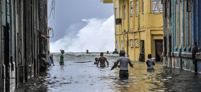
Flooding in Havana after Hurricane Irma, September 2017.
by Yisell Rodríguez Milán
and Danae González Del Toro
“An important biological species is facing the risk of extinction given the rapid and progressive elimination of its natural conditions for life: humanity”
—Fidel Castro Ruz (Earth Summit, Río de Janeiro, June 12, 1992)
What is to be done about high temperatures, rising sea levels, and increasingly powerful hurricanes? What can we do to be less vulnerable to climate change? Preliminary observations by groups of specialists in the country indicate that sea level has increased on the island an average of 6.77 centimeters since 1966, a process that has accelerated during the last five years. Since the middle of the last century, the average annual temperature has risen 0.9 degrees Celsius, and the coastline is today more fragile than ever. This reality calls for action, and Cuba is acting on the premise of preparing, to avoid lamenting later.
Tarea Vida (Project Life) is the country’s most ambitious project addressing climate change. The plan was approved April 25, 2017, by the Council of Ministers and refers to the ideas Fidel expressed at the Earth Summit held in Río de Janeiro, June12, 1992, where he emphasized the seriousness of threats to the human species.
The project led by the Ministry of Science, Technology, and Environment (Citma) is the most all-encompassing and comprehensive drafted to date. With a broad scope and superior organization, it includes and updates the local dimension, citing locations and actions to be taken in the short term (by 2020), long term (by 2050), and long range (2100). It outlines five strategic actions and 11 projects to counteract the impact being felt in vulnerable areas.
Odalys Goycochea Cardoso, Citma environmental director, told the press that the plan is comprehensive, and includes the identification of prioritized areas and sites, effects, and steps to be taken. She added that the program is being constantly enriched and expanded as its implementation progresses.
Action Research
“Projections for the future indicate that the average increase in sea level could reach 27 centimeters by 2050, and 85 by 2100, values that fall within the estimated ranges for the entire planet. This implies a slow reduction in dry land and a gradual increase in salinization, meaning that our underground aquifers will be impacted at a level that must be taken into consideration,” explained Rudy Montero, lead expert within the Environmental Agency’s risk assessment group.
Given this picture, 103 studies have been conducted on dangers, vulnerability, and risks related to weather and precipitation, including the impact of high winds, coastal flooding, and heavy rain. Likewise, research on drought, wildfires, risks of a geological, technological, or health nature have been considered, in order to take action in terms of prevention, preparation, response, and recovery — to confront and reduce risks and vulnerabilities “to adapt to this phenomenon that affects all,” Montero said.
Coastal flooding produced by extreme weather phenomena has been identified as one of the main dangers from climate change. These floods impact human constructions and the natural environment, and along with rising sea levels, put a number of settlements at risk. “We have identified them, and are going to work on new land use plans for each one.”
Among the strategic measures being implemented is the prohibition of any new construction of dwelling in the most vulnerable threatened coastal settlements, particularly those that are eventually may be become inundated. The project also calls for reducing population density in low-lying areas and ensuring that all new construction is well-adapted to the environment.
Agriculture and livestock ranching also figure among priorities to be addressed, given their importance to the country’s food security. Several actions projected address changes in land use patterns as a consequence of rising sea levels and drought: these include reducing cultivated areas along the coastline and in areas affected by saltwater instrusion, diversifying crops, improving soils, and introducing and developing varieties resistant to higher temperatures. Also projected is a process of reordering urban planning in identified settlements, and consideration of threatened infrastructure, in accordance with the country’s economic situation.
Accomplishments so far
Although Citma is the main body responsible for Tarea Vida, the project necessarily involves many ministries and agencies. In carrying out this joint work, Guantánamo is among the provinces that has made the most progress. Reforestation of coastal ecosystems, the construction of water treatment plants, and the promotion of environmentally friendly agricultural practices are just a few examples of what has been accomplished.
The Ministry of Agriculture (Minag), for its part, is working on replanting mangroves to reduce coastal erosion in this eastern province. Efforts are underway in several vulnerable areas, including the communities of Boca, Mata, and Barrancadero.
While their specialists are promoting agro-ecological practices to improve soils and conducting other community participation efforts.
“Thanks to this interest, the Yacabo Arriba mountain ecosystem has recovered some 20 hectares affected by erosion and the impact of Hurricane Matthew,” Clark Feoktistova, Citma representative in the province, told the press this past January 25.
The program of conservation measures to ensure sustainable land use, and protect soils, has been implemented in all of Guantánamo’s municipalities, he indicated, on state farms, and within cooperatives of both types, credit and services and agricultural production.
In an effort to mitigate the impact of drought in the province, the National Institute of Water Resources has undertaken, among other projects, the construction of several water treatment plants in the municipalities of Niceto Pérez, Manuel Tames and Maisí, along with the drilling of 12 wells to access water in underground aquifers to supply the population.
For its part, the province of Ciego de Ávila has prioritized the use of technology to promote water conservation. Looking to reduce leaks in its distribution network and protect groundwater, key to economic and social life, more than 6,000 meters have been installed in homes, principally in the provincial capital, Morón, and Majagua, according to Héctor Rosabales Pérez, water infrastructure director in the province.
Another short term mitigation effort is the replenishment of sand on beaches on the province’s northern keys, that have experienced erosion. This is a problem affecting many areas in the country, including Las Tunas where the impact has been strong.
In addition to the deterioration of sandy beaches along the northern coast, agriculture in this province has been affected by drought and high levels of salt water instrusion in fields close to the coastline, in the municipality of Puerto Padre. Given these difficulties, the Las Tunas Administrative Council created a multi-disciplinary team to manage the Tarea Vida work.
“Several agencies are decisive to the project, such as Physical Planning, that is the guiding body in terms of land use; the University, given its contribution of knowledge via research: the Ministry of Agriculture as responsible for soil resources, among other institutions that must combine forces to achieve the objective,” stated Amado Luis Palma, environmental management specialist for the Citma office in Las Tunas.
The province of Sancti Spíritus has also made progress with the implementation of Tarea Vida. The Sur de Jíbaro Agro-industrial Grain Enterprise and the Rice Research Station have done outstanding work in the development of varieties resistant to salinity and drought stress. Of equal importance has been the repair and recovery of irrigation canals to protect the fresh water they carry to the coastline, to help reduce the salt wedge.
Climate change is impacting this province mainly in the form of rising sea levels, which is affecting beaches, tourist development, and agricultural production.
Leonel Díaz, Citma representative in Sancti Spíritus, explained that saltwater instrusion, soil erosion, and the disappearance of mangroves have severely affected the municipalities of Sierpe and Sancti Spíritus.
Over the years, he added, a number of steps have been taken to mitigate the environmental impact of climate change, including important educational work in communities to raise awareness.
Saving Lives
Cuba’s high level of vulnerability as an island nation, makes rising sea levels precisely the element that most affects the country, in terms of climate change.
In a recent interview in Juventud Rebelde, Elba Rosa Pérez Montoya, minister of Science, Technology and the Environment, stated ” Tarea Vida involves everyone.”
Thus during her travels around the country, she has prioritized exchanges with provincial authorities, local Party leaders, representatives of Central State Administration bodies, Civil Defense, Physical Planning, and provincial risk assessment centers. She also believes raising consciousness about climate change in the population is essential, so that everyone is involved in action to meet the challenge.
“The projects are highly complicated, since environmental investments must be made, which are characterized by their significant cost and special requirements. Those that have been made are based on the research of many scientists, and are today systematized,” the Minister said.
Among Tarea Vida’s 11 projects are identifying and implementing projects to adapt to climate change, assuring the availability and efficient use of water to confront drought, reforesting to protect soils and water, stopping the deterioration of coral reefs by restoring and protecting them, and measures, plans, and projects linked to renewable energy, food security, health, and tourism.
Also included are protecting urban waterfronts, relocating at-risk human settlements, integrating recovery of beaches, mangroves, and other protective natural ecosystems, waterworks and coastal engineering projects.
Priorities are based on protecting human life in the most vulnerable areas, food security, and the development of tourism.
While Tarea Vida is being enriched as it is being implemented over time, and as action is taken, Cuba is aware that what is most important is foreseeing and confronting climate change. The ambitious, complex project shows the government’s determination to reduce vulnerability and raise risk perception
Eleven Projects included in State Plan “Tarea Vida”
Project 1: Identify and implement actions and projects to adapt to climate change, of a comprehensive, ongoing nature, needed to reduce existing vulnerability in the 15 identified priority zones. To be considered, to determine the order of these actions, are the population threatened, their physical safety and food security, and the development of tourism.
Project 2: Implement legal norms needed to execute the state plan, as well as assure their strict enforcement, with particular attention to measures directed toward vulnerability of constructed properties, prioritizing threatened coastal communities.
Project 3: Conserve, maintain, and recover the Cuban archipelago’s sandy beaches, prioritizing those urbanized for tourist use and reducing the structural vulnerability of constructed properties.
Project 4: Assure the availability and efficient use of water as part of confronting drought, on the basis of technology for conservation and satisfying the demands of locations. Improve water infrastructure and its maintenance, while taking action to measure the efficient and productive use of water.
Project 5: Direct reforestation toward providing maximum protection of soils and water in terms of both quantity and quality, as well as the recovery of the most affected mangroves. Prioritize reservoirs, canals, and the regulatory banks of tributaries leading to the island’s principal bays and coasts.
Project 6: Stop deterioration, renovate, and protect coral reefs throughout the archipelago, with priority for those bordering the insular platform, and protect urbanized beaches used for tourist purposes. Avoid over-fishing of species that benefit corals.
Project 7: Maintain, and add to plans, territorial and urban land use stipulations that emerged from the Macro-project on Dangers and Vulnerability of Coastal Zones 2050-2100, as well as Studies of Dangers, Vulnerability, and Risks in the disaster preparedness effort. Employ this information as an early warning to make decisions.
Project 8: Implement and supervise implementation of climate change adaptation and mitigation measures, which emerge from sector policies in programs, plans, and projects linked to food security, renewable energy, energy efficiency, land use, fishing, agriculture, health, tourism, construction, transport, industry, and the comprehensive management of forests.
Project 9: Strengthen monitoring systems, vigilance, and early warning plans to systematically evaluate the condition and quality of coastal zones, water, drought, forests, as well as human and plant health.
Project 10: Prioritize measures and actions to increase risk perception, understanding of, and participation by the entire population in confronting climate change, and a culture that promotes water conservation.
Project 11: Manage and use available international financial resources, both those from global and regional climate funds, and those from bilateral sources, to make investments, carry out actions, and implement projects related to the tasks outlined in the state plan.
Priority zones, areas, and sites
- The southern regions of Artemisa and Mayabeque
- Havana’s shoreline
- Havana Bay
- Mariel Special Development Zone
- Varadero and its tourist corridor
- Villa Clara’s resort keys
- Ciego de Ávila’s northern resort keys
- Ciego de Ávila’s northern and southern coastlines
- Camagüey’s resort keys and northern coastline
- Holguín’s northern coastline
- Santiago de Cuba Bay
- Coastal cities threatened by gradually rising sea levels: Cienfuegos, Manzanillo, Moa, Niquero, and Baracoa.
- Coastal settlements expected to be permanently inundated between 2050 and 2100 located in the provinces of Sancti Spíritus, Camagüey, Pinar del Río, and Villa Clara
- Sandy beaches facing severe erosion that could disappear if impacted by an extreme weather event; and others of tourist and recreational interest, located in the provinces of Camagüey, Pinar del Río, Granma, Holguín, Las Tunas, and he Isle of Youth.
- Unprotected coastal areas facing saline intrusion, located in the provinces of Pinar del Río, Matanzas, Granma, Camagüey, Cienfuegos, and Sancti Spíritus.
Very impressive program which can be a model for the world. Congratulations.