


[Photo: Ministro de Agroindustria de la Provincia de Buenos Aires]
(This article includes material provided by Lancaster University.)
In a previous article, I discussed the role of genetically modified corn and soybean seeds in driving rapid expansion in large scale monocrop agriculture in Argentina and nearby countries, contributing to rapid loss of biodiversity. A new study, published last week in the journal Science, shows that those giant farms have also made the South American plains more vulnerable to destructive flooding.
Extensive areas of grasslands, and forests across South American plains have rapidly been converted to the production of annual crops, such as soybean and maize. This agricultural expansion has been taking place at a staggering rate of 2.1 million hectares a year.
The new study shows how these shifts to annual crop agriculture, which relies on rainfall rather than irrigation, are rapidly disrupting the water table across the large flat regions of the Pampas and Chaco plains and contributing to significantly increased risks of surface flooding.
The researchers used satellite imagery and field observations over the last four decades, as well as statistical modelling and hydrological simulations, to identify trends for groundwater and flooding. They revealed unprecedented evidence on how subtle, but widespread changes to vegetation cover can transform the water cycle across large regions.
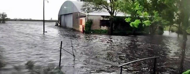
The replacement of native vegetation and pastures with rain-fed croplands in South America’s major grain-producing area has resulted in a significant increase in the number of floods, and the area they affect. New flooded areas are expanding at about 700 square kilometers per year in the central plains, a phenomenon unseen elsewhere on the continent.
As short-rooted annual crops replace deeper-rooted native vegetation and pastures, floods are gradually doubling their coverage and becoming more sensitive to changes in precipitation. Groundwater, once deep beneath the surface (12-6 meters), is now rising to shallower levels (around 4 meters).
Replacing deeper rooted trees, plants and grasses with shallow rooted annual crops over such a huge scale has moved the regional water table rise closer to the surface. As the water level rises closer to the surface there is less capacity for the land to absorb heavy rainfall, making flooding more likely.
In addition to flooding, researchers say these human-induced hydrological changes are also risking other issues such as soil erosion, methane emissions and salting of the land through salination.
The authors say the findings underscore the urgent need for smarter land use policies that promote sustainable farming practices and water management strategies.
| Science, June 29, 2023 Abstract: Agricultural expansion raises groundwater and increases flooding in the South American plains Regional effects of farming on hydrology are associated mostly with irrigation. In this work, we show how rainfed agriculture can also leave large-scale imprints. The extent and speed of farming expansion across the South American plains over the past four decades provide an unprecedented case of the effects of rainfed farming on hydrology. Remote sensing analysis shows that as annual crops replaced native vegetation and pastures, floods gradually doubled their coverage, increasing their sensitivity to precipitation. Groundwater shifted from deep (12 to 6 meters) to shallow (4 to 0 meters) states, reducing drawdown levels. Field studies and simulations suggest that declining rooting depths and evapotranspiration in croplands are the causes of this hydrological transformation. These findings show the escalating flooding risks associated with rainfed agriculture expansion at subcontinental and decadal scales. |